As I mentioned in my previous post, maps are created at various scales, in order to show certain features, and to maximize their value to different users. The whole map-making process has always been a huge amount of work.
If you like maps and math, there are jobs available today! Checking online, I see 7 listings for the Federal Government and other jobs with private industry. If you want to know the sort of things a mapmaker does, go see Cartographer Interviews.
Today, building upon existing maps and throwing lots of time and money at the problem, we can have maps almost any way we like. People who do this include XYZ Map Company, Tele Atlas, Navteq, Garmin, DeLorme, Thomas Maps, Google and so on, not to mention the civilian and military government agencies. Taking photos from satellites or moving vehicles is one thing, making maps is quite another!
Here's a time-lapse video of a map being built:
I decided to create photos and assemble some maps to the AnsMar offices in Poway, in case you want to come visit us. These were created today with an iPhone.
Here's a photo of our building - from a hand-held camera.
Now, a digital satellite photo hybrid with street names overlaid. The iPhone is showing the position where I am standing.
The same view, zoomed in (down) for more detail.
The same shot zoomed out (up) for better sense of where we are.
The view as a map rather than a photo
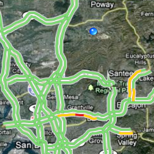
A larger hybrid view of the region showing live reports of highway traffic. I have to stay away from eastbound Interstate 8, where the yellow and red are showing. Notice all the small roads are missing.
A map view zoomed way way out showing the Pacific Ocean, Arizona, Nevada, Utah and Mexico. Only a few major cities and highways are shown. You can also see state and national parks, and state and national borders.
Here are the directions for walking from our office to the airport (not a good idea).
Driving takes 6 3/4 hours less time.
Turn-by-turn driving instructions accompanied with maps. The blue spot moves as you drive along.
Where's the math in this? Everywhere!


No comments:
Post a Comment
Type your comment here